Research objectives and methodology
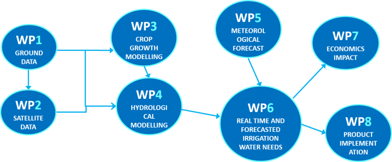
The research methodology is based on a multi-disciplinary approach that links together satellite data, ground measurements and numerical models all of them oriented to develop an operative forecast tool of water needs for irrigation.
The objective of the proposal is to develop and apply a tool for real-time forecast of crop water needs, to support interventions to reduce water losses in agriculture in case of dry or more severe drought periods and to promote a more sustainable use of the water in agriculture, supporting parsimonious water irrigation management at basin scale moving from the need of a single farmer. The different case studies represents the different spatial scale from farm to basin and also the respective end users needs (farmers, irrigation consortia, and river basin authority).
In addition to the above operative objective, several scientific objectives will be addressed.
The objectives stated above will be achieved through a number of interconnected and synergic activities, which are divided in work packages (WP), with their own deliverables and milestones.
WP Leader: POLIMI
Task.0.1: meetings, internal communication and reports.
Task.0.2: End-user involvement
Task.0.3: dissemination
WP Leader: UCD
WP Participants: UVEG, RADI-CAS, POLIMI, End-Users, ANBI
Task.1.1: Case studies description
Task 1.2: Real time meteorological data for hydrological models input
Task 1.3: Soil moisture and evapotranspiration data for the hydrological models validation at farm and basin scale
Task 1.4: Radiometric data for satellite data calibration/validation
WP Participants: CESBIO, RADI-CAS, UCD
Task 2.1: Time series of Leaf Area Index (LAI), fractional vegetation cover (FV), Albedo
Task 2.2: Time series of land surface temperature
Task 2.3: Time series of soil moisture
Task 2.4: Real time data
WP Leader: UNITUS
WP Participants: POLIMI
Task 3.1: Implementation of the crop growth model coupled with the hydrological model
WP Leader: POLIMI
WP Participants: RADI-CAS, UCD
Task 4.1: Implementation of the Hydrological models
Task 4.2: Calibration and Validation Intercomparison of the two hydrological models
WP Leader: EPSON
WP Participants: UVEG
Task 5.1: Comparison of modelling techniques in WRF
Task 5.2: Analysis of Spatial Scale in forecasting lead-time
Task 5.3: Real time forecast of meteorological forcings
WP Leader: POLIMI
WP Participants: RADI-CAS, UNITUS, UCD
Task 6.1: Satellite data assimilation into the hydrological model in real-time
Task 6.2: Water need forecast from evapotranspiration or soil moisture estimates
Task 6.3: Effect of different techniques of meteorological modelling forecast into hydrological modelling
WP Leader: UNITUS
WP Participants: ANBI
Task 7.1: Assessing private costs and benefits of water use for irrigation.
Task 7.2: Assessment of the public benefits associated with the adoption of the parsimonious irrigation technology
WP Leader: POLIMI
WP Participants: ANBI, EPSON, UNITUS, End-Users
Task 8.1: operative tool implementation.
Task 8.2: Interaction with the end users
Task 8.3: the business plan